
 Translate
Fish Passage Restoration Program
This program removes structures in streams and rivers that block salmon from reaching historic habitat. This will allow salmon to reach miles of historic spawning and rearing habitat. Access to more habitat will help ensure healthy salmon populations.
Connecting salmon to their historic habitat
In King County, our roads and trails cross many streams. Culverts are pipes that carry streams under roads and trails. Many culverts and other structures in streams block salmon from reaching upstream habitat. Fish passage projects remedy these barriers to allow salmon to reach historic habitat.
When we travel on roads and trails around the county, we don't notice how many streams we cross. We enjoy movement without barriers to our passage. Fish passage projects remove barriers in streams for salmon. This means that salmon can swim upstream to good habitat. Other animals that live near streams also use these projects to move between areas.
Abundant salmon have been important to the way of life here for thousands of years. Restoring fish passage to historic stream habitat is one of the best ways to help salmon. Helping salmon is essential to increase salmon numbers. And more salmon will provide endangered Southern Resident Killer Whales with vital food.
The program works to speed up salmon habitat restoration by restoring fish passage. This involves removing barriers that block salmon from reaching productive habitats. To gain habitat faster, the program works to build projects faster. To better connect salmon to habitat, the program partners with other barrier owners to increase fish passage work throughout the county.
Working to fix fish passage barriers
The King County Fish Passage Restoration Program provides a roadmap to success. This requires:
- a regional approach driven by data,
- strong partnerships,
- enough funding, and
- a flexible permitting process.
Most fish passage barriers are metal or concrete pipes, known as culverts. Culverts carry streams underneath roads, trails, and railroads. In King County, many culverts are decades old. Older culverts are often too small, too steep, or have a waterfall coming out of them.
Many culverts resemble firehoses, pushing water through at a high speed. Over time, this condition makes culverts impossible for salmon to swim through. Water gushing from culverts often erodes a deep hole in the streambed downstream. This prevents fish from being able to jump high enough to enter the culvert. The resulting waterfall out of the culvert creates a fish passage barrier.
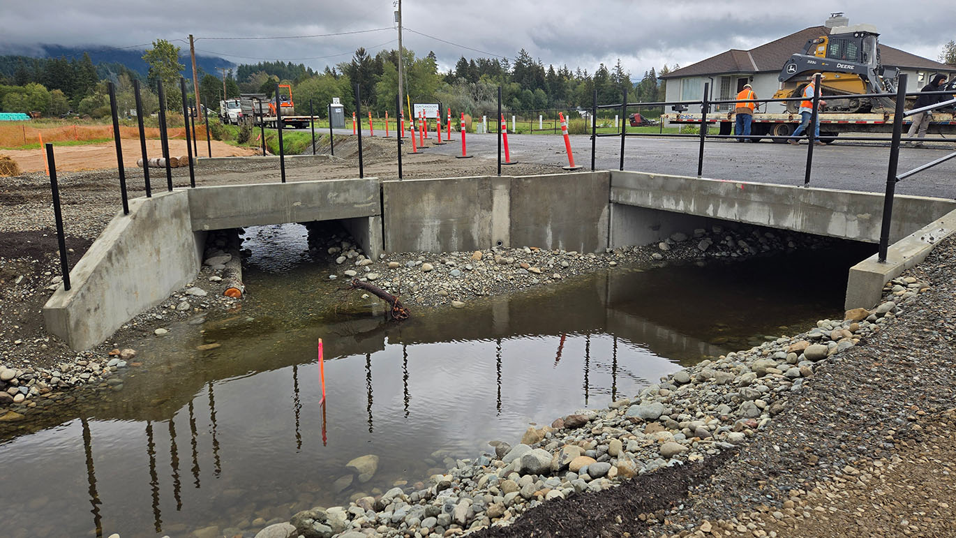
Modern culverts look more like bridges and arches than pipes. They are big enough to allow the stream in the culvert to resemble a natural stream. This means that it's easy for fish and other aquatic life to move upstream or downstream through them.
Before: Most fish passage barriers are metal or concrete pipes, known as culverts

After: Modern culverts look more like bridges and arches than pipes

Prioritizing which barriers to remove first to achieve the best results
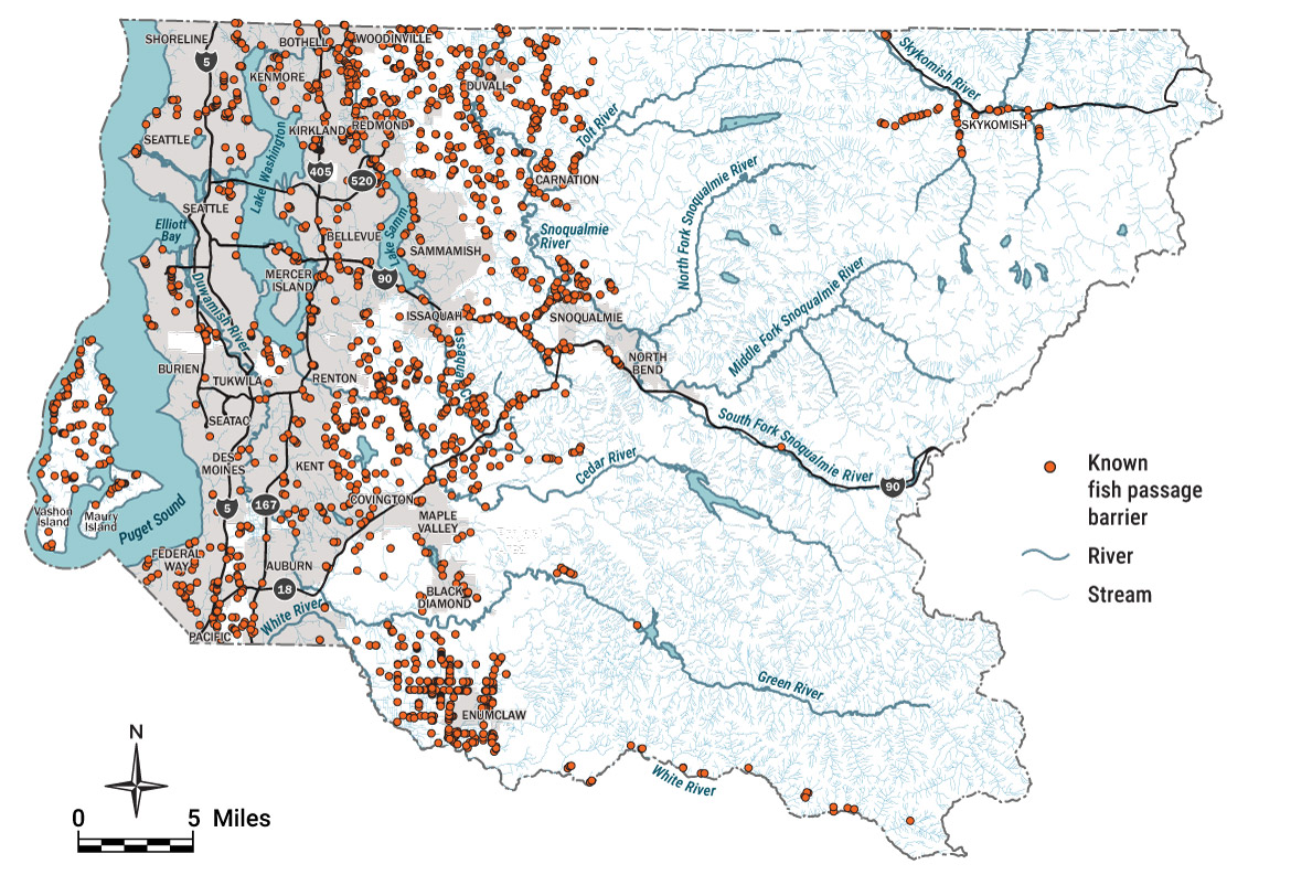
King County scientists and engineers have identified the best locations to remove barriers. In 2019, the County started a comprehensive inventory of county-owned barriers. By 2022, King County field crews completed an inventory of thousands of locations. The crews evaluated each site to see if it was a fish passage barrier. The surveyed locations are along county-owned roads, trails, and on county property.
The field inventory found roughly 1,000 county-owned fish passage barriers. It also found about 500 county-owned structures that are not barriers. Some of these barriers prevent many salmon from swimming to high-quality habitat. We wanted to find out where fish passage projects can produce the best results for salmon.
With partners, the County developed a formula to score barriers. The scoring measures the habitat benefits of a barrier remedy at county-owned barriers. The program then used the formula to find out where fixing barriers benefit salmon the most.
The scoring formula considers the following factors:
- The quality of upstream habitat;
- The amount of upstream habitat;
- The other barriers on the stream; and
- If the stream provides Chinook or kokanee habitat.
The county developed a point system to credibly evaluate the relative salmon benefits of each county barrier. The highest possible score is 100 points.
All scored barriers would benefit at least one species of salmon.
The higher the score for a barrier, the higher priority for restoring fish passage at the barrier. The scoring allows the county to better plan fish passage projects. We can achieve more habitat gain with fish passage projects at the high scoring barriers.
At the same time, county departments identified aging barriers at risk of failure. During repairs of these structures, the projects restore salmon passage to meaningful habitat.
The County used the scoring data and lists of at-risk barriers to draft a fish passage work plan.
See reports from 2021 and 2022 for details about the inventory and scoring analysis:
King County Fish Passage Barrier Prioritization Summary Report (743 KB), June 2022
Final Report Regarding Remedies to Existing Fish Passage Barriers for King County (1.9 MB), March 2021
Access the county’s fish passage data:
GIS data for the King County fish passage barrier inventory and prioritization scoring
King County fish passage barriers
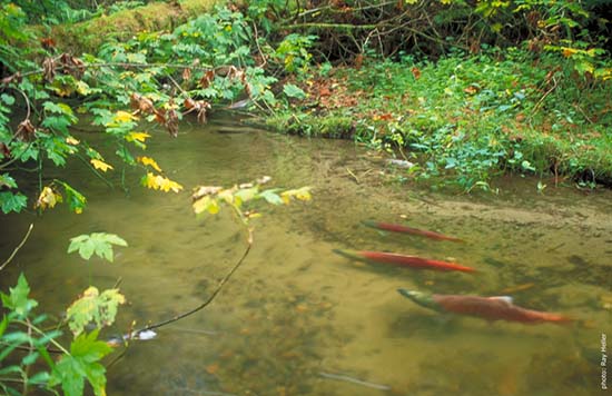
Sockeye returning to Bear Creek near Woodinville
Action to connect salmon to habitat
Since 2018, the county has invested more than $40 million on dozens of fish passage projects. From 2019 to 2025, the county has restored salmon passage at 33 barriers. This has opened up 55 miles of stream habitat for salmon which county barriers blocked.
Since 2023, a work plan for fish passage has guided the program. The plan identifies 74 projects for completion between 2023 and 2039. Between 2020 and 2025, the County has completed 29 fish passage projects. This includes 8 projects on the 2023-2029 work plan.
By 2039, the County plans to complete 95 fish passage projects. This consists of 29 projects already completed plus 66 planned projects. This is about ten percent of county barriers. The planned work will restore salmon access to at least half, or 50 percent of the habitat that county barriers blocked in 2020. Compared project selection with no barrier scoring, the County will be able to gain about five times more habitat gain with the work plan. This shows how the program uses data to gain salmon habitat faster.
The program estimates the remaining projects will cost about $250 million (in 2025 dollars).
To gain habitat faster, the program works to build projects faster. This means streamlining planning, design, and construction of fish passage projects by:
- Standardizing procedures;
- Developing programmatic approaches; and
- Enhancing collaboration with partners inside and outside of the county.
Efficiencies in project execution will benefit all fish passage restoration efforts.
Salmon don’t care who owns a barrier that blocks them from swimming upstream. More than 3,000 salmon passage barriers exist in King County (the county owns about 1,000 of these). So connecting salmon to upstream habitat requires collaboration among all barrier owners. King County partners with others to increase fish passage restoration across the county. Partners include other barrier owners, salmon restoration groups, and county residents. The County works to build relationships toward:
- Providing technical support;
- Seeking cooperative funding, and
- Cooperating to link up fish passage projects on important streams.
Together, partnerships help link up nearby projects to increase habitat gains for salmon.
We’re also exploring options to close the gap between the current funding and the amount of funding we’ll need. Possible funding and financing options include:
- Maximizing grant funding;
- Flexible regulatory approaches that allow mitigation focused on high scoring barrier remedies;
- Public-private partnerships; and
- Public funding options like future levy proposals and bonds that need voter approval.
The barrier inventory and scoring provide the groundwork for future fish passage work. As a result, King County is very competitive for grants for fish passage.
Measuring progress
The potential upstream habitat gain is more than 300 miles of stream. This measures the habitat gain from one county-owned barrier to the next. It doesn’t consider intervening non-county barriers. But it represents the amount of potential salmon habitat blocked by county barriers. The name of this metric is “county habitat gain potential.” This is the best way to determine the potential habitat gain that's the direct responsibility of the County. Over time, new barriers are found and other barriers get remedied in ways that the county doesn't control. County habitat gain potential is the best way to track habitat outcomes over time since this metric is within the County's control.
King County habitat gain potential

Immediate habitat gain

The immediate habitat gain is at least 150 miles of stream (based on a snapshot of conditions in May 2025). This is the habitat gain that salmon see right after project completion. Barriers not owned by the county occur on these same streams. This habitat gain measures the habitat upstream to the next known barrier. The name of this metric is “immediate habitat gain.” Immediate habitat gain can change a lot based on mapping of barriers. For example, it might increase with completion of upstream fish passage projects. It can also decrease with new assessments that identify unknown barriers upstream. This makes immediate habitat gain a poor metric to track habitat outcomes over time.
2020-2024 progress toward program habitat outcomes
The figure below is a bar graph showing progress for King County fish passage work from 2020 to 2024, for several metrics. The bar graph shows the percent complete of the 2020 to 2039 work plan targets. Twenty-one percent of the total number of fish passage projects are complete. Between 11 and 15 percent of the total habitat gain target has been achieved, looking at habitat gain based on habitat units and miles of gain, for county habitat gain potential and immediate habitat gain.

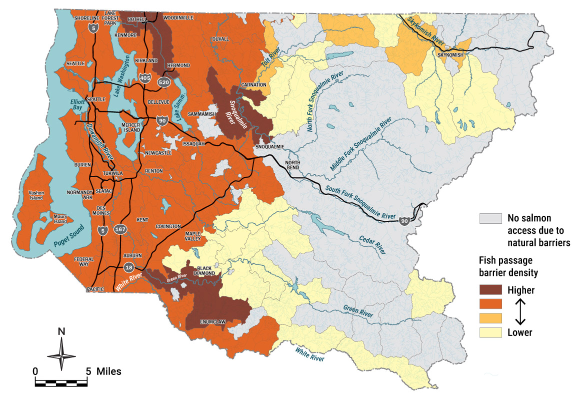
2024 fish passage barrier density (barriers per stream length)
The map of King County, Washington below shows the fish passage barrier density by stream subbasin. Higher densities cluster in the western part of the county. Lower densities occur further east in subbasins in the foothills of the Cascade Mountains.
Story map
News and announcements
Download the King County Fish Passage GIS Data!
Sept. 30, 2025
Fish Passage Restoration Program Strategic Plan (3.2 MB)
Mar. 12, 2024
Performance Audit by the King County Auditor
Fish Passage Restoration: Opportunities to Increase Impact, Transparency, and Collaboration
Nov. 22, 2024
External report, KING5 News
Dead salmon spotted in Enumclaw. Here's why experts say it's a good thing
Oct. 6, 2022
External article, Seattle Times
Buttigieg wades into Northwest salmon transportation
June 2022
King County Fish Passage Barrier Prioritization Summary Report (743 KB)
Aug. 16, 2021
A united effort to remove barriers to salmon habitat
May 16, 2021
External article, Seattle Times
King County’s culvert hunters — and a $9 billion plan to save salmon habitat
Feb. 26, 2021
Field team inventories 3,000 potential barriers to fish habitat.
Nov. 6, 2020
Downstream News
New King County road across Mary Olson Creek improves transportation for people and salmon
Oct. 23, 2020
External article, Seattle Times
WSDOT tries a ‘bridge-in-a-backpack’ in Duvall as an innovative way to replace fish-blocking culverts
Sept. 27, 2019
The fish passage field team is at the frontline of King County’s effort to protect and restore salmon habitat
Jul. 31, 2019
External report, KOMO News
State investing $25 million to remove culverts for salmon migration