
 Translate
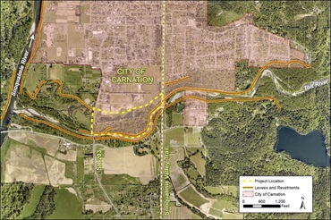
Lower Frew Levee Setback Project
Project overview
The Lower Frew Levee Setback project is in the City of Carnation on the northern bank of the Tolt River, between SR 203 and the Snoqualmie Valley Trail. King County, as the primary service provider to the King County Flood Control District, will replace the existing levee with a new levee built farther away from the river and replace a frequently flooded culvert under State Route (SR) 203 with a new raised bridge. This will help reduce flood risks, improve vehicle access on SR 203 during floods, and improve habitat along the lower Tolt River.
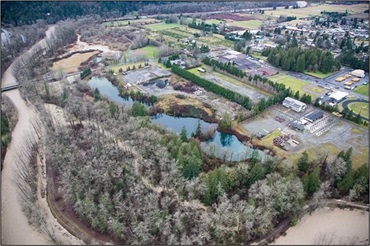
Most levees on the Tolt River were built more than 60 years ago to reduce flooding. However, the unintended result was that the levees disconnected the river from floodplain which resulted in inadequate and unequal levels of protection throughout the river system. Building a new levee farther from the river will reconnect the river to 34 acres of its historical floodplain and will reduce riverbank erosion and flood risk to people, property, roads, and bridges. It will also provide critical habitat for fish.
The recreational Tolt River Trail will be rebuilt on the new setback levee, which will reduce the frequency of trail closures and damages due to flooding. The trail will provide a link between the Snoqualmie Valley Trail and Tolt MacDonald Park with a goal of safe recreational user access at SR 203.
The project is expected to begin construction in 2027.
What is a levee?
A levee is a raised structure built along a riverbank to contain, control, or divert the flow of water and protect the land along the river from temporary flooding. A levee is usually made of earth and runs parallel to the course of a river.
Fish habitat conservation
The King County Flood Control District and King County are working to protect and restore fish habitat on the Tolt River. The Tolt River is home to Chinook salmon, bull trout, and steelhead trout. These species are all listed as threatened under the Endangered Species Act. In addition to reducing flood risks, this project has the added benefit of supporting fish recovery by restoring access to a side channel of the river. Fish need side channels to lay eggs and protect young fish from predators. A goal of this project is to restore river processes and functions in order to improve salmon spawning and rearing habitat. This project will connect to 44 acres of previously restored floodplain habitat downstream of SR 203.
Project goals
- Identify how the project can best reduce flood risks, improve habitat and provide recreation opportunities by gathering input from residents, tribes, the City of Carnation, and other interested parties.
- Reduce flood and riverbank erosion risks to people, property, roads, and bridges.
- Improve habitat for salmon and other fish.
- Limit disruption to SR 203, Tolt MacDonald Park, and recreational trails during construction.
Anticipated schedule
| Activity | Date |
| Collect data and information | 2020 to 2022 (Complete) |
| Alternatives analysis and selection | 2022 to 2023 (Complete) |
| Design and permitting | 2024 to 2026 (In progress) |
| Target construction start | 2027 |
Project documents
In 2022, King County developed design alternatives based on project goals and objectives, technical studies, and input from tribes, the public, project partners, and other relevant parties.
Links to design alternatives are on the engagement hub site.
The King County Flood Control District selected Alternative 4b in November 2023. This design is consistent with the Tolt River Levee Level of Service Analysis recommendations for levee height, and it provides the highest level of flood risk reduction and habitat benefit of all alternatives evaluated. It is responsive to public input on pedestrian safety and will connect the new trail to Tolt MacDonald Park with a grade-separated trail crossing at SR 203. It is also the most resilient design for changing climate conditions at SR 203. Preliminary design began December 2023, and a consultant team has been hired to lead elements of the design.
Community engagement
During the project alternative development and evaluation phase, the project team shared information and sought input from local tribes, regulatory agencies, partner agencies, the public and other interested parties. Project updates and meeting announcements are shared on this website, through the GovDelivery list (subscribe here), and on social media. Public meetings and engagement opportunities to date include:
- Carnation City Council meetings – May and June 2022
- Booth at Carnation’s “Be Dam Ready” community event – September 2022
- Public meeting, Carnation Senior Center – October 2022
- Virtual open house via King County’s Engagement Hub survey- open May 2024- January 2025
Construction impacts
King County is working to limit the impacts of construction. Traffic control and potential road or lane closures to SR 203 may be necessary at times during construction. King County will close the Tolt River Trail between SR 203 and the Snoqualmie Valley Trail for safety during construction.
We will update this webpage with further impacts to SR 203, Tolt MacDonald Park, and trails in the area as the project moves through design and permitting. We will also post signs and flyers near the project site and notify local businesses and residents before and during construction. To receive updates, please sign up for the project email list.