
 Translate
North Fork Snoqualmie River Confluence Revetment Removal Project
Community engagement
Community, tribal, and partner input prior to January 30, 2025, will be considered as the project moves into the project design phase. Sign up to receive project updates and notification of opportunities to provide feedback.
Project overview
In October 2024, the King County Flood Control District selected the project alternative to remove the Scott Revetment on the North Fork Snoqualmie River. The Scott Revetment was built around the year 1960. The purpose of the Scott Revetment was to reduce erosion of a privately-owned property used for livestock grazing. Today, the project area, shown in the image on the left, is entirely within Three Forks Park.
Why remove this revetment? The area behind the Scott Revetment is now a natural area owned by King County Parks. The revetment is not needed because it no longer protects farmland, structures, roads, or other infrastructure, yet public funds are still being spent to inspect and maintain it.
- Since the Scott Revetment is no longer needed, it was identified as an ideal companion project to the Mason Thorson Ells Levee Rehabilitation Project, which was another King County Flood Control District project recently implemented by King County. The Mason Thorson Ells Levee Rehabilitation Project offered a good opportunity for a companion restoration project, given the nature and extent of the needed repairs and project constraints, which limited on-site habitat enhancement.
- Impacts to recreational users: There is recreational use in the area, especially during the summer. Removing the revetment will result in a more natural riverbank that may change where visitors access the river. Project construction is currently scheduled to start in August 2025. Outreach will inform recreational users and neighbors of planned construction. Signs will be placed in the river to warn water users who have not seen prior notices of construction.
Project location
The North Fork Snoqualmie River confluence area is located where the Middle and North Fork Snoqualmie rivers merge, in Three Forks County Park between the cities of Snoqualmie and North Bend. The project location is on the south side of the North Fork Snoqualmie River, downstream of the bridge on 428th Avenue Southeast.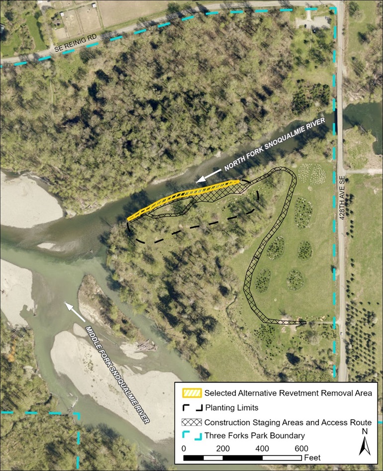
What is a revetment?
A revetment is a structure built along a riverbank to prevent erosion. Revetments are usually built with rocks, wood, and other materials. Native plants are added to the riverbank to improve stability and provide habitat for fish and wildlife.

Current rock armoring of the Scott Revetment.
Project goals
- Avoid long-term costs of inspecting and maintaining river protection facilities that no longer protect critical public infrastructure, private property, or farmland.
- Improve natural river processes that will improve the connection between the North Fork Snoqualmie River and its floodplain.
- Improve habitat for fish and wildlife.
- Share information about floodplain management activities and nearby projects through educational signage in collaboration with King County Parks.
- Incorporate public input into the selection of the project alternative and project design.
Contruction impacts
King County is working to limit the impacts of construction. The Scott Revetment will be removed in Summer 2025. The project site, downstream of the 428th Ave SE bridge on the south side of the North Fork Snoqualmie River, will be inaccessible during construction. However, construction will not block passage on the water. Several alder trees will have to be removed to safely remove the revetment. Efforts will be made to retain most of the mature cottonwood trees shown in the Alternative 1 map, below. In their place, approximately 2 acres of native trees and shrubs will be planted. These native plants will enhance habitat for fish and wildlife.
We expect few impacts to roads, sidewalks, trails, or parks as the project is constructed. In water use will be directed to the opposite side of the river. We will also post signs near the project site and on the river and notify local residents and in-water users before and during construction. To receive updates, please sign up for project announcements.
Selected Project Alternative
Two project alternatives were considered. Many elements were similar between both options offered: all result in removing approximately 570 linear feet of revetment and artificial material along the riverbank. In addition, invasive plants will be removed, native shrubs and trees will be planted along the river, and educational signage will be designed and installed in the project vicinity.
Several factors were considered in the development of the two alternatives:
- The geomorphic uncertainty of how the river would reshape the newly exposed bank, potential flood risks to upstream residents
- A desire to retain mature trees as much as possible
- Recreational water user safety, and
- Potential benefits to recreation and habitat improvements.
The main difference between the two alternatives was the amount of bank grading done after the revetment removal – Alternative 1 allows the shape of the bank to largely be determined by natural river processes over time while Alternative 2 included more bank grading that would lay create a shallower slope in selected locations.
The King County Flood Control District selected Alternative 1, as shown in the image below. The project team, in collaboration with Snoqualmie Tribe staff, are now working on a more detailed design.
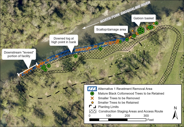
Alternative 1 Revetment Removal Area
Project schedule (subject to change)
| Activity | Date |
|---|---|
| Community engagement | 2024 |
| Alternative selection | Q3 2024 |
| Final design and permits | Q2 2025 |
| Anticipated construction completed | August 25 - September 19, 2025 |
| Tree and Shrub planting complete | Q4 2025 |
| Monitoring | Through 2029 |