
 Translate
Critical Areas - Overview and related permits
What is a critical area?
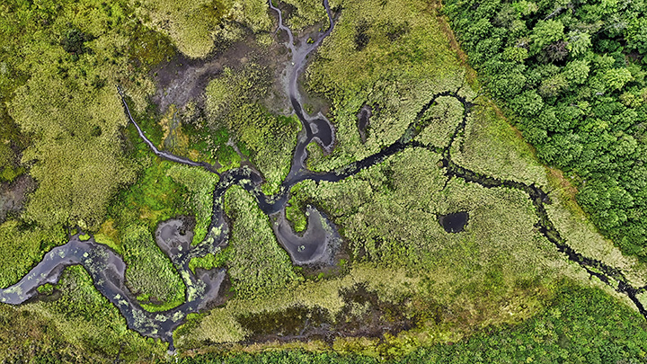
The term “critical area” refers to land that merits special protection because of its ecological value or importance to public health or safety.
Critical areas are defined in state law as:
- Wetlands;
- Areas with a critical recharging effect on aquifers used for potable water, known as Critical Aquifer Recharge Areas or CARAs;
- Fish and wildlife habitat conservation areas, such as riparian areas, aquatic areas, and species of local importance;
- Frequently flooded areas; and
- Geologically hazardous areas, such as landslide hazard areas, erosion hazard areas, and seismic hazard areas.
King County, like other cities and counties, is required by state law to adopt regulations that protect critical areas as well as their buffers from damage, keep them healthy and functioning, and protect public health and safety. Local governments are required to include best available science in the development of policies and regulations to protect critical areas.
New updates to critical area regulations
The Critical Area Ordinance (CAO) is a set of King County regulations that govern how critical areas must be protected in unincorporated King County. The purpose is to protect public health or safety and the environment.
State law requires local governments review and, if necessary, update their CAO at least once every 10 years with major comprehensive plan updates. King County’s most recent 10-year comprehensive plan update was adopted in 2024, and updates to CAO regulations were due by the end of December 2025.
The King County Council adopted the updated CAO on December 2, 2025. These regulations, excluding those that apply to critical areas located within the shoreline jurisdiction, go into effect on February 18, 2026.
Key changes driven by the best available science include:
- Stronger protections for native plants and trees along streams and rivers.
- Enhanced protections for wetlands that are difficult or impossible to replace, like bogs and wetlands along our saltwater shorelines.
- Strengthening and clarifying standards to avoid, minimize, and mitigate for development impacts to wetlands and streams.
- Ensuring that regulations recognize and support established, ongoing commercial agriculture.
- Clarifying how Farm Management Plans supporting more flexible regulations are reviewed, approved, and monitored.
- Updating standards for some types of agricultural development such as farm field access drives, grazing, and farm-related structures.
- New alluvial fan standards that limit new, at-risk development in alluvial fan hazard areas, clarify requirements for emergency actions, and support flood risk reduction projects sponsored by the Flood Control District or Department of Natural Resources and Parks.
- Allowing "climate-adaptive plants" to be used in mitigation and restoration projects, supporting climate resilience.
You can find the ordinance here: Ordinance 20024
Frequently asked questions
Here are some questions and answers about the updated regulations. If you have a question that this FAQ does not cover, contact Permitting's Customer Service.
The CAO is a set of King County regulations that govern how critical areas must be protected in unincorporated King County. Critical areas include both environmentally sensitive areas and hazard areas. The purpose of critical areas regulations is to protect public health or safety and the environment.
Critical areas are defined in state law as:
- Wetlands;
- Areas with a critical recharging effect on aquifers used for potable water, known as Critical Aquifer Recharge Areas or CARAs;
- Fish and wildlife habitat conservation areas, such as riparian areas, aquatic areas, and species of local importance;
- Frequently flooded areas; and
- Geologically hazardous areas, such as landslide hazard areas, erosion hazard areas, and seismic hazard areas.
For some critical areas, adopted maps show where the areas are located and are used as the basis for applying regulations. This is the case for Critical Aquifer Recharge Areas or CARAs, wildlife habitat networks, erosion hazard areas, channel migration zones, tsunami hazard areas, and some flood hazard areas.
For all other critical areas, location, extent, and classification are determined by King County based on information presented in a site-specific critical area report conducted by an ecological or geological professional. The critical area report is based on definitions and standards in the King County Code. The county's online mapping system, iMap, provides information about the general location of some critical areas, but it is not suitable for determining the exact location and classification of the critical area. Permit applicants are responsible for locating and disclosing the presence of critical areas and any associated buffers on the development proposal site.
The update to the CAO clarifies critical areas identification and analysis requirements. The Department of Local Services, Permitting Division (Permitting) will provide bulletins in 2026 to support customers in understanding the requirements.
The Critical Areas Ordinance (CAO) update expands buffers around certain critical areas in unincorporated King County to protect public health and safety, and to promote environmental health in the region. Certain building and development activities are restricted within buffer areas around critical areas.
When a development proposal occurs near a critical area (such as a wetland, stream, or steep slope), an applicant may be asked to provide additional information with the permit application so Department of Local Services, Permitting Division (Permitting) staff can assess how the proposed development might impact these critical areas. If you have questions, please contact Permitting's Customer Service.
Depending on the activity you wish to pursue on your property, and whether that activity or construction is allowable, you may have to complete additional steps and/or a different process and pay additional fees to obtain a permit compared to properties not near a critical area.
Permit fees can be found here: Permit fees - Building and land use - King County, Washington
When a development proposal occurs near a wetland, lake, wildlife habitat or stream, an applicant may be required to provide additional information with the permit application to enable Permitting staff to better assess potential impacts the development might have on these critical areas. Information that may be required in a critical area report commonly includes wetland delineation and rating, stream delineation and type, wildlife habitat assessment, and/or geological hazard risk assessment, which must be completed by a qualified professional. Based on the critical area report, Permitting staff verify the limits of critical areas and their buffers as they apply to the proposal. Critical areas can also be determined through a Critical Areas Designation (CAD) prior to applying for a development permit. The extents and classifications of critical areas determined by a CAD are valid for five years from the approval date.
In addition, development proposals that encroach into a stream, wetland, or buffer will require a Critical Area Mitigation Plan. Small projects, such as those involving less than 1,000 square feet of buffer impact, can typically apply the Restoration and Enhancement Guidelines to develop a plan. These mitigation and enhancement plans are also used when there has been unpermitted activity, such as clearing and grading, in a critical area or buffer to help get the property owner back into compliance with code and the critical area better protected. In some cases, when onsite mitigation opportunity is limited, offsite mitigation through a mitigation bank or in-lieu fee program may be necessary.
Vesting depends on whether a CAD is effective when the permit is deemed complete. Under KCC 21A.24.500(E), a CAD is effective if it is within five years of issuance, with no site changes and no updated state or federal maps.
- New CAD applications and all other permit applications without an effective CAD:
- Permit application submitted on or after February 18 → new CAO applies.
- Permit application submitted before February 18:
- If the application is deemed complete within 28-day triage → prior CAO applies.
- If the application is deemed incomplete during triage and later deemed complete on or after February 18 → new CAO applies.
- Permit applications with an effective CAD (within the five-year effectiveness period, no change in site conditions, and no updated state/federal maps determined under KCC21A.24.500(E)):
- If the CAD letter was dated before August 2023, the language of the CAD vested the existence, location, and classification of critical areas and critical area buffer widths to the prior CAO.
- If the CAD letter was dated after August 2023, the language of the CAD clarified in more detail what information was included in the determination. The existence, location, and classification of on-site critical areas is vested, but all regulations including buffers must comply with the new CAO for applications submitted on or after February 18.
*Important Note: An effective CAD is a decision regarding critical areas on a site and does not automatically vest a project to all local ordinances.
Agriculture FAQ
Customer bulletins
We’ve developed the following bulletins to support customers and reflect the recent updates to the CAO. We will be revising these materials as new information becomes available. Check back regularly for the most current guidance, documentation, and updates related to the updated critical areas regulations.
Alluvial Fan Hazard Area Guidance
Affidavit Concerning Critical Areas Compliance
Consultant Guidance Ecological Information
Critical Areas Restoration and Enhancement
Critical Areas Designation Guidance
Critical Areas Mitigation Guidelines
Critical Areas Alteration Exception Instructions Information
Critical Areas Alteration Exception Application Public Agency
Critical Area Alteration Exception Application for Private Development
Ecological Critical Area Report Criteria
Geological Critical Areas Report Guidance
Landslide Hazard Area Guidance
Reasonable Use Exception Instructions Information
Reasonable Use Exception Application
How do I know if I have critical areas on my property?
Development restrictions vary between different types of critical areas, and King County Code (KCC) Chapter 21A.24 lays out what is allowed and under what conditions. In all cases, development proposals must make every effort to avoid impacts to critical areas and minimize and mitigate any impacts that cannot be avoided.
Critical area report (CAR)
If your development proposal occurs near wetlands, streams, lakes, steep slopes, or other critical areas, you likely will need to provide additional information, such as a critical area report, with your permit application.
If you are not sure whether critical areas are on or near your property, you may need to hire a private environmental consultant to review your property. King County iMap can be a useful source of preliminary information, especially for geologic hazards, but is not a complete picture.
Critical area designation (CAD)
Property owners can request that King County Permitting determine the existence, location, and classification of critical areas on their project site before applying for a development or land use permit. This Critical Areas Designation (CAD) can help inform property owners about how critical areas may affect a proposed project early in the design phase before beginning the permitting process. The CAD is required before applying to Seattle-King County Public Health for a septic system design or well site approval for residential projects. Learn more: Critical Area Designation Guidance.
Exceptions
A critical area alteration exception is a process that allows an applicant to propose an alteration that would otherwise be prohibited by critical area regulations in KCC 21A.24. A proposal that directly impacts wetlands, aquatic areas, or wildlife habitat conservation areas typically requires a reasonable use exception instead. The application must meet all applicable conditions in KCC 21A.24.070 as well as the criteria for approval in KCC 21A.44.030, as it a type of variance. For more information: Critical Areas Alteration Exception Instructions Information and Reasonable Use Exception Instructions Information.
Flood Hazards and Floodplain Development
Flood Hazard Certification
Floodplain Development Permit
Floodplain, FEMA Elevation Certificate
Important Note: After clicking the link above, you may see an error message page starting with "Please wait..." Please ignore this message. Proceed to save the PDF to your computer using the top-left floppy disk icon. Then, reopen the file from the saved location to view the full document. You can navigate between instructions and form view by clicking the "Form Instructions" button at the top of page three when you first open the file. This document is a duplicate from FEMA's website here.