
 Translate
Boise Creek Mitigation Project
Project description
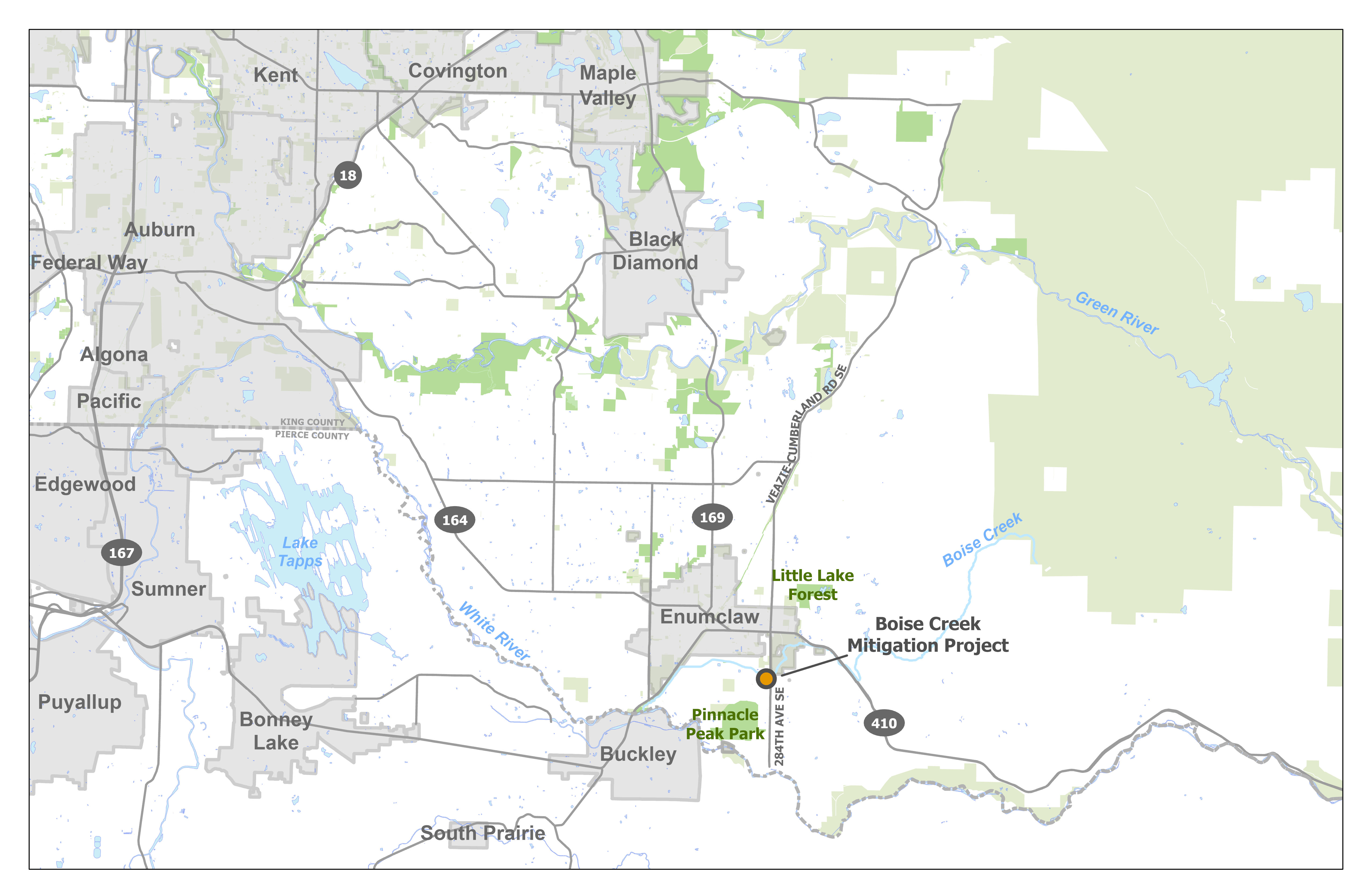
The Boise Creek Mitigation Project is located on a 5.19-acre portion of the Middle Boise Creek Natural Area on the left bank of Boise Creek downstream from 284th Ave SE. The Boise Creek Mitigation Project will create wetland and aquatic habitat while preserving native riparian buffers. Construction begins in 2026, and the completed project will create 2.6 acres of new wetland and aquatic area. The Boise Creek Mitigation Project will compensate for unavoidable permitted impacts to wetlands and aquatic resources in Water Resource Inventory Area (WRIA) 10.
Background
Boise Creek is extremely important to the Puyallup/White River Watershed because it provides spawning and rearing habitat for Chinook salmon (spring, fall runs) and steelhead trout. Coho, pink, and chum salmon, and cutthroat trout are also present in Boise Creek. Boise Creek is degraded due to past land use activities and water temperatures in Boise Creek consistently exceed state standards for salmon spawning and incubation. There is a significant lack of woody vegetation, and consequently, shade to the creek.
Boise Creek is identified in the Salmon Habitat Protection and Restoration Strategy for Puyallup and Chambers Watersheds as a high priority tributary for restoration and protection of natural geomorphic processes and riparian function. King County has successfully implemented three salmon restoration projects on Boise Creek downstream of the Boise Creek Mitigation Project. The Boise Creek Mitigation Project will complement these successful projects and add rearing and refuge habitat for salmon further upstream. The project will protect riparian habitat and is expected to improve water quality, while adding needed salmonid habitat on Boise Creek. Wetlands will be established with large wood and diverse native vegetation. The Boise Creek Mitigation Project will provide mitigation credits for King County’s Mitigation Reserves Program.
Vicinity map
Pre-construction aerial

Project design
The Boise Creek Mitigation Project will establish wetland and aquatic features and enhance riparian habitat. Plans include salvaging a bridge for reuse, fill removal, installation of large and small habitat wood and native plantings.
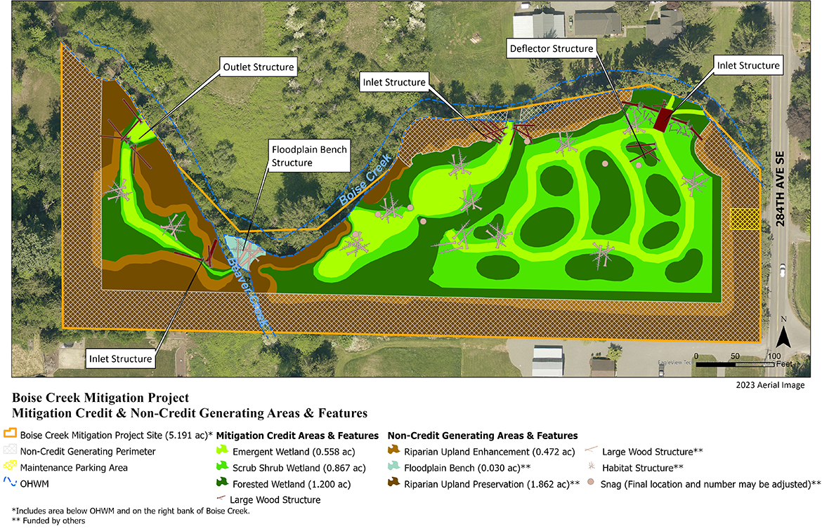
100% Design Plan View
Barn and Bridge Reuse
Creating new salmon habitat required removing existing built infrastructure, so King County looked for ways to preserve and reuse materials wherever possible. Before construction of the Boise Creek Mitigation Project, a barn built in the 1930s stood on the property. Rather than demolish it, in spring 2025, King County used an innovative approach called panelization to remove large sections of the structure intact. Water and Land Resources Division collaborated with Solid Waste Division, Parks Division, and the Historic Preservation Program to identify and pursue this process for building removal and reuse. The contractor who removed the barn has already reused sections of the barn’s roofing and lumber to build a guest cabin, and plans are underway to repurpose additional materials for a farm store.
The barn isn’t the only structure being salvaged. A bridge on the property is also slated for reuse. Because the banks of Boise Creek will be reconfigured to expand and improve salmon habitat, the bridge no longer serves a purpose in its current location. Due to its excellent condition and modular construction, the bridge will be salvaged and reused by King County Roads, likely to replace an aging bridge. Reuse projects like these, reduce waste, and use less energy to build than traditional construction projects, delivering both environmental and community benefits.
Project schedule
| Boise Creek Mitigation Project schedule overview | |
|---|---|
|
Alternatives analysis complete |
August 2022 |
|
30% design plans complete |
September 2023 |
|
60% design plans complete |
August 2024 |
|
90% design plans complete |
November 2024 |
|
Implementation |
Summer - Fall 2026 |
|
Monitoring |
2027-2036 |